Learn how to know the usual traffic of a place before traveling and avoid traffic jams and headaches. In some circumstances, it may be necessary to find out what the traffic is like in a certain area. For example, if we are moving to live elsewhere and we need to know what our usual route to work or school will be like, to assess how long it might take us to get there and leave well in advance.
Previously we had told you how to know which direction you are oriented in Google Maps, now we are going to teach you how to know the usual traffic between two points in Google Maps. It is very easy to do, it only takes a few minutes to have this information.
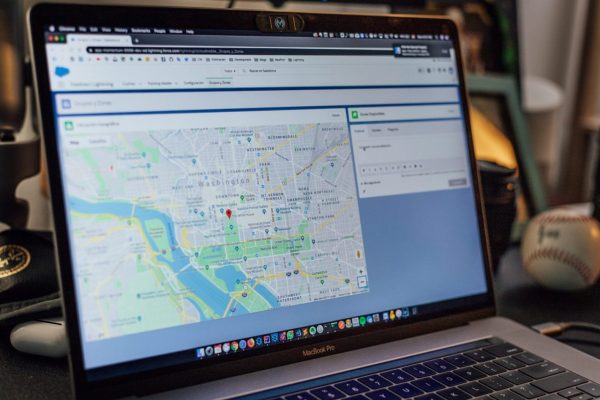
You Can See How The Traffic Between Two Addresses is Usually on Google Maps
The first thing we have to do is open the Google maps application and enter the address of the place we want to go to in the search bar that appears at the top of the screen.
By default our current location will be the starting point to get to the place we have chosen, if you want to know how to get there from another point, simply write the address in the corresponding field.
Then press the Indications button.
Enter the address of the place you want to get to in Google Maps and then tap Directions.
Then you must press on the three dots in the upper right corner to open the menu and select set departure or arrival time.
You will see a list of numbers that scroll vertically to select a departure time, generally, we will place there the time in which we usually have to leave our house to reach our usual destination.
Open the menu and select Set departure or arrival time
Next, clicking on Today will open the calendar so that we can choose any date and find out how the traffic usually is during that journey on the day and time that we choose. Perhaps it is best to select Friday since it is usually the day with the most traffic, so we can know more exactly how long the trip would take us on a day when the traffic is quite intense.
Selecting Today will open the calendar to choose a date.
After you have selected the day and time, click on Set and you will see the information you need about typical travel times between the two points you selected.
Press Set and you will see the information you need about typical travel times between the two points you selected.
Did you know that you can also measure the distance between two points in Google Maps? Follow these steps.
Do You Need a Different Means of Transport?
If you don’t usually drive and need to use public transport, you can know what your trip will be like using different means of transport, such as the train, the subway, or the bus.
You can also check the time the trip takes by different means of transport.
To do this, follow the following steps:
- Open the Google Maps app on your smartphone or tablet.
- At the bottom, tap Go.
- Search or type your destination in the search bar at the top.
- At the bottom, tap Directions.
- At the top, select your means of transport.
- Select your preferred route.
- At the bottom, tap Pin.
In Google Maps You Can See the Traffic Now and Later
You can also check the current traffic before leaving and avoid peak hours of the day, roadblocks, delays due to accidents, etc.
- Launch the Google Maps app on your smartphone or tablet.
- Search for a destination or touch a place on the map.
- At the bottom, tap Directions.
- At the top, tap Drive.
- At the bottom, tap the white bar to display the following:
- Current traffic on your route
- The usual hourly traffic and any delays along the way
Information About Events on Your Route
When looking at your daily commute traffic, you might see notable events such as the following:
- Concerts
- Parades
- Marathons
- Sports events
On days when there are events, you will be able to receive the following types of updates:
- Delays
- Closed routes
- Traffic conditions
- Alternative routes
At the end of the event, the information also disappears and is updated.
You can also use Google Maps offline by following the steps we teach you in this tutorial
Now you know how to know in advance the traffic between two points with Google Maps.
Surely this information will help you avoid a few headaches when planning your daily trip and you will not have to worry about being late anywhere.
Tell us if you find this information useful, and we will be happy to see your comments.